| Philippine Rise | |
|---|---|
| |
| Location | Philippine Sea |
| Nearest city | Ilagan, Philippines |
| Coordinates | 16°30′N 124°45′E / 16.500°N 124.750°E |
| Area | 13,000,000 ha (50,000 sq mi)[1] |
| Designation | Protected food supply exclusive zone[2] |
| Designated | May 2017[2] |
| Governing body | Government of the Philippines (recognized by the United Nations since 2012) |
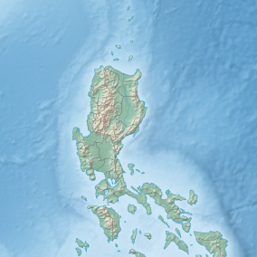
The Benham Rise, formally designated as Philippine Rise by the Philippine government, is an extinct volcanic ridge located in the Philippine Sea approximately 250 kilometers (160 mi) east of the northern coastline of Dinapigue, Isabela. The rise has been known to the people of Catanduanes as Kalipung-awan, which literally means "loneliness from an isolated place", as early as the precolonial era of the Philippines.[3][4][5]
Under the Philippine Sea lie a number of basins including the West Philippine Basin, inside of which is located the Central Basin Fault (CBF).[6] The Philippine Plateau is located in the CBF and its geologic basement probably is a micro-continent.[7] Several scientific surveys have been made on the feature to study its nature and its impact on tectonic subduction, including one about its effects on the 1990 Luzon earthquake. The Philippines claimed this feature as part of its continental shelf in a claim filed with the United Nations Commission on the Limits of the Continental Shelf on April 8, 2009, and which was approved under the United Nations Convention on the Law of the Sea (UNCLOS) in 2012.[8]
The rise is designated as a "protected food supply exclusive zone" by the Philippine government since May 2017. Mining and oil exploration are banned in the Philippine Plateau as it is a protected area. On May 16, 2017, President Rodrigo Duterte signed Executive Order No. 25, renaming the feature to "Philippine Rise".[9][10]
- ^ "FAST FACTS: What you should know about Philippine Rise". March 18, 2017.
- ^ a b "Benham Rise, now known as PHL Rise, declared Protected Food Supply Exclusive Zone". May 11, 2017.
- ^ "On untranslatable words from Philippine languages". CNN Philippines. Archived from the original on December 18, 2020. Retrieved October 26, 2019.
- ^ Avendaño, Christine O. "Duterte renames Benham Rise Philippine Rise". Philippine Daily Inquirer.
- ^ Pulta, Benjamin. "What is the Philippine Rise?". Philippine News Agency. Retrieved June 12, 2021.
- ^ Hickey-Vargas, R.; Sato, H.; Machida, S.; Ishii, T.; Hirano, N.; Yumul, G.; Fujioka, K. (2001). "Isotopic Characteristics of Basalts From the Central Basin Fault, West Philippine Basin". AGU Fall Meeting Abstracts. 2001. Harvard University: T41C–0893. Bibcode:2001AGUFM.T41C0893H.
Fall Meeting 2001
- ^ Avijit Gupta (February 24, 2005). The physical geography of Southeast Asia (2005 ed.). Oxford University Press. p. 14. ISBN 0-19-924802-8. - Total pages: 440
- ^ "UN approves PH territorial claim to Benham Rise". Philippine Daily Inquirer. Retrieved April 28, 2012.
- ^ Viray, P.L. (May 22, 2017). "Duterte renames 'Benham Rise' to 'Philippine Rise'". The Philippine Star. Retrieved May 22, 2017.
- ^ "[ EXECUTIVE ORDER NO. 25, May 16, 2017 ]". Philippine Supreme Court E-Library.


