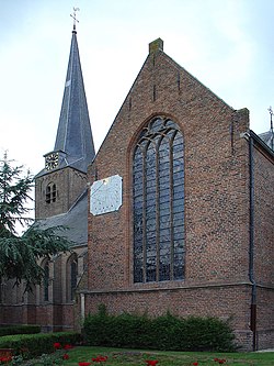
Benschop | |
|---|---|
Village | |
 De Nicolaaskerk van Benschop | |
| Coordinates: 52°0′26″N 4°58′46″E / 52.00722°N 4.97944°E | |
| Country | Netherlands |
| Province | Utrecht |
| Municipality | Lopik |
| Area | |
| • Total | 22.97 km2 (8.87 sq mi) |
| Elevation | −0.4 m (−1.3 ft) |
| Population (2021)[1] | |
| • Total | 3,575 |
| • Density | 160/km2 (400/sq mi) |
| Time zone | UTC+1 (CET) |
| • Summer (DST) | UTC+2 (CEST) |
| Postal code | 3405[1] |
| Dialing code | 0348 |
Benschop is a village in the Dutch province of Utrecht. It is a part of the municipality of Lopik, and lies about 4 km west of IJsselstein. Benschop is an extremely long village: apart from a relatively compact town centre, it consists of a long ribbon (over 8 km long) of houses (mainly farms) on both sides of the Benschopsche Wetering. Until 1989, Benschop was a separate municipality.
- ^ a b c "Kerncijfers wijken en buurten 2021". Central Bureau of Statistics. Retrieved 28 March 2022.
two entries
- ^ "Postcodetool for 3405AA". Actueel Hoogtebestand Nederland (in Dutch). Het Waterschapshuis. Retrieved 28 March 2022.

