| Bentley Park Queensland | |||||||||||||||
|---|---|---|---|---|---|---|---|---|---|---|---|---|---|---|---|
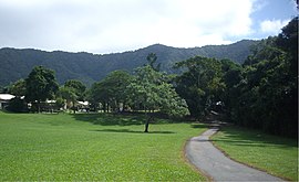
 View from Bentley Park, QLD with Fletcher Court and Lamb Range, QLD in background | |||||||||||||||
 | |||||||||||||||
| Coordinates | 17°00′39″S 145°43′23″E / 17.0108°S 145.7230°E | ||||||||||||||
| Population | 8,360 (2021 census)[1] | ||||||||||||||
| • Density | 1,212/km2 (3,138/sq mi) | ||||||||||||||
| Postcode(s) | 4869 | ||||||||||||||
| Area | 6.9 km2 (2.7 sq mi) | ||||||||||||||
| Location |
| ||||||||||||||
| LGA(s) | Cairns Region | ||||||||||||||
| State electorate(s) | Mulgrave | ||||||||||||||
| Federal division(s) | Kennedy | ||||||||||||||
| |||||||||||||||
Bentley Park is a suburb of Cairns within the local government area of Cairns Region, Queensland, Australia.[2] It is located approximately 9 km (6 mi) south of the Cairns City. In the 2021 census, Bentley Park had a population of 8,360 people.[1]
- ^ a b Cite error: The named reference
Census2021was invoked but never defined (see the help page). - ^ "Bentley Park (entry 45559)". Queensland Place Names. Queensland Government. Retrieved 15 April 2014.
