Benton County | |
|---|---|
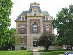
 Benton County Courthouse in Fowler, Indiana. | |
 Location within the U.S. state of Indiana | |
 Indiana's location within the U.S. | |
| Coordinates: 40°37′N 87°19′W / 40.61°N 87.31°W | |
| Country | |
| State | |
| Founded | February 18, 1840 |
| Named for | Senator Thomas H. Benton |
| Seat | Fowler |
| Largest city | Fowler |
| Area | |
• Total | 406.51 sq mi (1,052.9 km2) |
| • Land | 406.42 sq mi (1,052.6 km2) |
| • Water | 0.09 sq mi (0.2 km2) 0.02% |
| Population (2020) | |
• Total | 8,719 |
| • Density | 21/sq mi (8.3/km2) |
| Time zone | UTC−5 (Eastern) |
| • Summer (DST) | UTC−4 (EDT) |
| Congressional district | 4th |
| Website | www |
| |
Benton County is located in the northwest part of the U.S. state of Indiana, along the border with Illinois. As of 2020, the county's population was 8,719.[1] It contains six incorporated towns as well as several small unincorporated settlements; it is divided into 11 townships which provide local services.[2][3] The county seat is Fowler.[4]
Benton County is part of the Lafayette, Indiana, Metropolitan Statistical Area.

- ^ "Benton County, Indiana". United States Census Bureau. Retrieved May 29, 2023.
- ^ "Benton". Indiana Township Association. Archived from the original on September 21, 2010. Retrieved September 12, 2010.
- ^ "Duties". United Township Association of Indiana. Retrieved January 6, 2011.
- ^ "Find a County – Benton County IN". National Association of Counties. Archived from the original on July 19, 2011. Retrieved January 6, 2011.
