Berchtesgaden | |
|---|---|
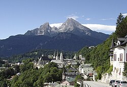
 Berchtesgaden and the Watzmann in August 2010 | |
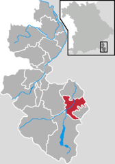
Location of Berchtesgaden within Berchtesgadener Land district  | |
| Coordinates: 47°37′53″N 13°0′15″E / 47.63139°N 13.00417°E | |
| Country | Germany |
| State | Bavaria |
| Admin. region | Oberbayern |
| District | Berchtesgadener Land |
| Government | |
| • Mayor (2020–26) | Franz Rasp[1] (CSU) |
| Area | |
| • Total | 34.78 km2 (13.43 sq mi) |
| Elevation | 700 m (2,300 ft) |
| Population (2023-12-31)[2] | |
| • Total | 7,698 |
| • Density | 220/km2 (570/sq mi) |
| Time zone | UTC+01:00 (CET) |
| • Summer (DST) | UTC+02:00 (CEST) |
| Postal codes | 83471 |
| Dialling codes | 08652 |
| Vehicle registration | BGL |
| Website | www |
Berchtesgaden (German pronunciation: [ˈbɛʁçtəsˌɡaːdn̩]) is a municipality in the district Berchtesgadener Land, Bavaria, in southeastern Germany, near the border with Austria, 30 km (19 mi) south of Salzburg and 180 km (110 mi) southeast of Munich. It lies in the Berchtesgaden Alps. South of the town, the Berchtesgaden National Park stretches along three parallel valleys.
The Kehlstein mountain (1,835 m or 6,020 ft), with its Kehlsteinhaus (Eagle's Nest), is located in the area.
- ^ Liste der ersten Bürgermeister/Oberbürgermeister in kreisangehörigen Gemeinden, Bayerisches Landesamt für Statistik, accessed 19 July 2021.
- ^ Genesis Online-Datenbank des Bayerischen Landesamtes für Statistik Tabelle 12411-003r Fortschreibung des Bevölkerungsstandes: Gemeinden, Stichtag (Einwohnerzahlen auf Grundlage des Zensus 2011).


