Bereket
Gazanjyk, Russian Cyrillic Казанджик (1895-1999) | |
|---|---|
 | |
| Coordinates: 39°14′35″N 55°31′01″E / 39.24306°N 55.51694°E | |
| Country | |
| Province | Balkan Province |
| District | Bereket District |
| Government | |
| • Häkim | Nurahmet Gylyjov |
| Area | |
• City | 18.632 km2 (7.194 sq mi) |
| • Urban | 9.342 km2 (3.607 sq mi) |
| Elevation | 205 m (673 ft) |
| Population (est. 2016) | |
• City | 24,500 |
| • Density | 1,314/km2 (3,400/sq mi) |
| Time zone | +5 GMT |
| Postal code | 745130 |
| Area code | +(993) 247 XX XXX |
Bereket, formerly Gazanjyk or Kazandzhik (Russian: Казанджик or Turkmen: Газанҗык gɑˈzɑnd͡ʒik), is a city in Balkan Province in western Turkmenistan. Bereket is the administrative centre of Bereket District.
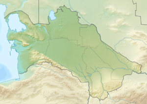
Bereket is located in an oasis in the foothills of the Kopetdag Mountains and on the edge of the Karakum Desert.
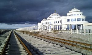
Bereket is a strategic junction of the Trans-Caspian Railway (Caspian Sea-Turkmenistan-Uzbekistan-Kazakhstan) and North-South Transnational Railway (Russia-Kazakhstan-Turkmenistan-Iran-Persian Gulf.[1][2]
The city has a large locomotive repair depot and a modern railway station.
The city is located approximately 260 km (162 mi) west of the Turkmen capital of Ashgabat and 340 km (211 mi) east of the Caspian Sea port of Turkmenbashy. The largest cities nearby are Balkanabat 120 km (75 mi) to the west, and Serdar 90 km (56 mi) to the east.
The estimated population of the city is 24,500 as of March 2015.
- ^ "North-South Transnational Corridor". railway-technology.com. Retrieved 2014-03-25.
- ^ "Crossing of Railways". turkmenistaninfo.ru. Retrieved 2014-03-25.
