| Bergse Maas / Bergsche Maas | |
|---|---|
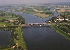
 Keizersveer bridge across the Bergse Maas near Geertruidenberg; to the right, the mouth of the Oude Maasje. | |
 | |
| Specifications | |
| Locks | None |
| Maximum height above sea level | 7 ft (2.1 m) |
| Status | Open |
| History | |
| Former names | Bergsche Maas |
| Modern name | Bergse Maas |
| Date of first use | 1904 |
| Date completed | 1904 |
| Geography | |
| Start point | River Meuse at Heusden |
| End point | Amer estuary at Geertruidenberg |
| Connects to | River Donge, river Oude Maasje |
 | |
The Bergsche Maas (Dutch pronunciation: [ˈbɛr(ə)xsə ˈmaːs]; current spelling: Bergsche Maas) is a canal that was constructed in 1904 to be a branch of the river Maas (French: Meuse) in the Dutch province of North Brabant. The Maas splits near Heusden into the Afgedamde Maas and the Bergse Maas. The Afgedamde Maas flows north until its confluence with the river Waal (the main distributary of the river Rhine) to form the Merwede, while the Bergse Maas continues west as the main distributary of the Maas. Part of the Merwede (the Nieuwe Merwede) rejoins the Bergse Maas to form the Hollands Diep estuary.