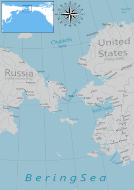
| Bering Strait | |
|---|---|
 The Bering Strait | |
 Nautical chart of the Bering Strait | |
| Location | North Asia and Northern America |
| Coordinates | 65°45′00″N 168°58′37″W / 65.75000°N 168.97694°W |
| Basin countries | Russia, United States |
| Min. width | 82 km (51 mi) |
| Average depth | 30–50 m (98–164 ft) |
| Max. depth | 90 m (300 ft) |
| Islands | Diomede Islands |
The Bering Strait (Russian: Берингов пролив, romanized: Beringov proliv) is a strait between the Pacific and Arctic oceans, separating the Chukchi Peninsula of the Russian Far East from the Seward Peninsula of Alaska. The present Russia-United States maritime boundary is at 168° 58' 37" W longitude, slightly south of the Arctic Circle at about 65° 40' N latitude. The Strait is named after Vitus Bering, a Danish-born Russian explorer.
The Bering Strait has been the subject of the scientific theory that humans migrated from Asia to North America across a land bridge known as Beringia when lower ocean levels – a result of glaciers locking up vast amounts of water – exposed a wide stretch of the sea floor,[1] both at the present strait and in the shallow sea north and south of it. This view of how Paleo-Indians entered America has been the dominant one for several decades and continues to be the most accepted one. Numerous successful crossings without the use of a boat have also been recorded since at least the early 20th century.
- ^ Beck, Roger B.; Linda Black; Larry S. Krieger; Phillip C. Naylor; Dahia Ibo Shabaka (1999). World History: Patterns of Interaction. Evanston, IL: McDougal Littell. ISBN 978-0-395-87274-1.
