Berkel en Rodenrijs | |
|---|---|
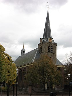
 Dorpskerk | |
 | |
| Coordinates: 51°59′N 4°28′E / 51.99°N 4.47°E | |
| Country | The Netherlands |
| Province | |
| Municipality | |
| Area | |
| • Total | 18.91 km2 (7.30 sq mi) |
| • Land | 18.62 km2 (7.19 sq mi) |
| • Water | 0.29 km2 (0.11 sq mi) |
| Population (January 2020) | |
| • Total | 31,650 |
| • Density | 1,700/km2 (4,300/sq mi) |
| Time zone | UTC+1 (CET) |
| • Summer (DST) | UTC+2 (CEST) |
| Postal code | 2651-2652 |
| Area code | 010 |
| Roads and Rail | N209, N470, N471, RandstadRail |

Berkel en Rodenrijs (Dutch pronunciation: [ˈbɛrkəl ɛn ˈroːdə(n)rɛis] ) is a town and former municipality in the municipality of Lansingerland, in the province of South Holland, The Netherlands. The town is very close to Rotterdam.


