| Berrigan Shire New South Wales | |||||||||||||||
|---|---|---|---|---|---|---|---|---|---|---|---|---|---|---|---|
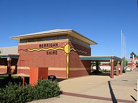
 Berrigan Shire Office, Chanter Street, Berrigan. | |||||||||||||||
 Location in New South Wales | |||||||||||||||
| Coordinates | 35°38′S 145°48′E / 35.633°S 145.800°E | ||||||||||||||
| Population |
| ||||||||||||||
| • Density | 4.0958/km2 (10.608/sq mi) | ||||||||||||||
| Established | 1906 | ||||||||||||||
| Area | 2,066 km2 (797.7 sq mi) | ||||||||||||||
| Mayor | Cr. Matt Hannan (Unaligned)[3] | ||||||||||||||
| Council seat | Berrigan | ||||||||||||||
| Region | Riverina | ||||||||||||||
| State electorate(s) | Murray | ||||||||||||||
| Federal division(s) | Farrer | ||||||||||||||
 | |||||||||||||||
| Website | Berrigan Shire | ||||||||||||||
| |||||||||||||||
Berrigan Shire is a local government area in the southern Riverina region of New South Wales, Australia. The Shire lies on the New South Wales State border with Victoria formed by the Murray River. The Shire is adjacent to the Newell and Riverina Highways. The Shire is a mainly agricultural region, with dairying, cattle raising, woolgrowing and cropping the main activities. The vast majority of the Shire is irrigated. Tourism is another major activity, concentrated on the river towns of Tocumwal and Barooga.
The mayor of Berrigan Shire is Cr. Matt Hannan, an unaligned politician.[3]
- ^ Australian Bureau of Statistics (27 June 2017). "Berrigan (A)". 2016 Census QuickStats. Retrieved 7 July 2017.
- ^ "3218.0 – Regional Population Growth, Australia, 2017-18". Australian Bureau of Statistics. 27 March 2019. Retrieved 27 March 2019. Estimated resident population (ERP) at 30 June 2018.
- ^ a b Cite error: The named reference
mayorwas invoked but never defined (see the help page).