Bethel, Connecticut | |
|---|---|
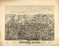
 1879 sketch of Bethel | |
| Coordinates: 41°22′15″N 73°24′50″W / 41.37083°N 73.41389°W | |
| State | Connecticut |
| County | Fairfield |
| Town | Bethel |
| Area | |
| • Total | 4.09 sq mi (10.59 km2) |
| • Land | 4.09 sq mi (10.59 km2) |
| • Water | 0.0 sq mi (0.0 km2) |
| Elevation | 384 ft (117 m) |
| Population (2010) | |
| • Total | 9,549 |
| • Density | 2,335/sq mi (901.4/km2) |
| ZIP Code | 06801 |
| FIPS code | 09-04790 |
| GNIS feature ID | 2378335 |
Bethel is a census-designated place (CDP) in Fairfield County, Connecticut, United States. It comprises the primary village and surrounding residential land within the town of Bethel. As of the 2010 census, the population of the CDP was 9,549,[1] out of 18,584 in the entire town.
- ^ "Profile of General Population and Housing Characteristics: 2010 Census Summary File 1 (DP-1), Bethel CDP, Connecticut". American FactFinder. U.S. Census Bureau. Archived from the original on February 13, 2020. Retrieved November 1, 2019.


