| Betsie River | |
|---|---|
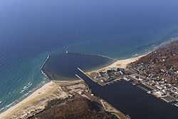
 Mouth of the Betsie River at Lake Michigan, in Frankfort | |
| Physical characteristics | |
| Source | |
| • location | Green Lake near Interlochen |
| • coordinates | 44°35′31″N 85°47′40″W / 44.5919459°N 85.794522°W[1] |
| Mouth | |
• location | Lake Michigan at Frankfort |
• coordinates | 44°37′45″N 86°14′45″W / 44.6291652°N 86.2459287°W[1] |
| Length | 54 mi (87 km) |
The Betsie River (/bɛtsiː/ BET-see) is a 54.0-mile-long (86.9 km)[2] river in the U.S. state of Michigan. The river is located in the northwestern Lower Peninsula of the state, flowing into Lake Michigan at Frankfort. The river's course is mostly within Benzie County, (which takes its name from a variant pronunciation of the river), although the river rises in western Grand Traverse County and flows briefly through northern Manistee County.
The river widens to form Betsie Lake before emptying into Lake Michigan between Frankfort and Elberta. The Betsie River is a part of Michigan's Natural Rivers Program.[3]

- ^ a b Cite error: The named reference
gnis1was invoked but never defined (see the help page). - ^ U.S. Geological Survey. National Hydrography Dataset high-resolution flowline data. The National Map Archived 2012-03-29 at the Wayback Machine, accessed November 21, 2011
- ^ Betsie River, Michigan Department of Natural Resources
