| Bhima River Chandrabhaga River | |
|---|---|
 Bhima at Pandharpur | |
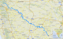
 Bhima river course [1] | |
| Location | |
| Country | India |
| State | Maharashtra, Karnataka, Telangana |
| Physical characteristics | |
| Source | Bhimashankar |
| • location | Maharashtra, India |
| • coordinates | 19°4′19″N 73°32′9″E / 19.07194°N 73.53583°E |
| • elevation | 945 m (3,100 ft) |
| Mouth | Krishna River |
• location | between Karnataka and Telangana about 24 km north of Raichur, India |
• coordinates | 16°24′36″N 77°17′6″E / 16.41000°N 77.28500°E |
• elevation | 336 m (1,102 ft) |
| Length | 861 km (535 mi) |
| Basin size | 70,614 km2 (27,264 sq mi) |
| Discharge | |
| • location | mouth |
| Basin features | |
| Tributaries | |
| • left | Ghod, Sina, Kagini |
| • right | Bhama, Indrayani, Mula-Mutha, Nira |
The Bhima River (also known as Chandrabhaga River) is a major river in Western and South India. It flows southeast for 861 kilometres (535 mi) through Maharashtra, Karnataka, and Telangana states, before joining the Krishna River. After the first sixty-five kilometers in a narrow valley through rugged terrain,[1] the banks open up and form a fertile agricultural area which is densely populated.[2]
The river is prone to drying up during the summer season.[clarification needed] In 2005, it caused severe flooding in Solapur, Vijayapura and Kalburgi districts. The river is also referred to as Chandrabhaga River, especially at Pandharpur, as it resembles the shape of the Moon.
- ^ Khan, Mirza Mehdy (1909). "Rivers". Hyderabad State. Imperial Gazetteer of India, Provincial Series. Calcutta: Superintendent of Government Printing. pp. 97–98. OCLC 65200528.
- ^ "Bhima River". Britannica Concise article. Archived from the original on 2 January 2013. Retrieved 11 December 2006.