Bhind district | |
|---|---|
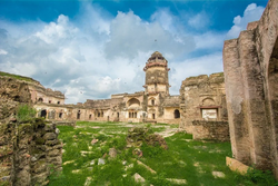
 Fort of Ater | |
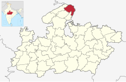
 Location of Bhind district in Madhya Pradesh | |
| Coordinates (Bhind): 26°36′N 78°48′E / 26.6°N 78.8°E | |
| Country | |
| State | Madhya Pradesh |
| Division | Chambal division |
| Headquarters | Bhind |
| Tehsils | 10: Bhind Rural, Bhind Urban, Ater, Gormi, Mau, Mehgaon, Gohad, Lahar, Mihona, Raun. |
| Government | |
| • District Magistrate | Sanjeev Kumar Shrivastava. IAS |
| • Lok Sabha constituencies | Bhind |
| • SP | Asit Yadav IPS |
| Area | |
• Total | 4,459 km2 (1,722 sq mi) |
| Population (2011)[1] | |
• Total | 1,703,005 |
| • Density | 380/km2 (990/sq mi) |
| Demographics | |
| • Literacy | 75.3 per cent |
| • Sex ratio | 838 |
| Language | |
| • Official | Hindi |
| • Dialect | Bundeli, Brijbhasa. |
| Time zone | UTC+05:30 (IST) |
| Vehicle registration | MP-30 |
| Major highways | NH 719 (earlier NH92) |
| Website | bhind |
Bhind district is a district in the Chambal division of the Indian state of Madhya Pradesh.
- ^ "Census of India: Bhind". www.censusindia.gov.in. Retrieved 9 October 2019.