Bhojpur
District ( Khikamakchha District)
भोजपुर जिल्ला ( खिकामाक्छा जिल्ला) | |
|---|---|
 Chandi Bazar: A famous spot of Kirat Rai Ubhauli festival in Balankha | |
 Location of Bhojpur district | |
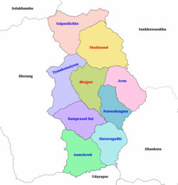
 Political division of Bhojpur | |
| Coordinates: 27°10′21″N 87°02′53″E / 27.17250°N 87.04806°E | |
| Country | |
| Province | Koshi Province |
| Admin HQ. | Bhojpur |
| Municipality | |
| Government | |
| • Type | Coordination committee |
| • Body | DCC, Bhojpur |
| • Head | Mr. Laxman Khadka |
| • Deputy-Head | Mrs. Anisha Khadka |
| • Parliamentary constituencies | 1 |
| • Provincial constituencies | 2 |
| Area | |
| • Total | 1,507 km2 (582 sq mi) |
| Highest elevation | 4,153 m (13,625 ft) |
| Lowest elevation | 153 m (502 ft) |
| Population (2021) | |
| • Total | 157,923 |
| • Density | 100/km2 (270/sq mi) |
| • Households | 39,393 |
| Demographics | |
| • Ethnic groups | |
| • Female ♀ | 53% |
| • Male ♂/100 female | 89.96 |
| Human Development Index | |
| • Income per capita (US dollars) | $999 |
| • Poverty rate | 24.4 |
| • Literacy | 69% |
| • Life Expectancy | 68.3 |
| Time zone | UTC+05:45 (NPT) |
| Postal Codes | 57000, 57001..., 57015 |
| Telephone Code | 029 |
| Main Language(s) | Nepali, Rai, Tamang |
| Major highways | Mid-Hills Highway |
| Website | ddcbhojpur |
Bhojpur District (Nepali: भोजपुर जिल्ला [bʱod͡zpur] ) is one of 14 districts of Koshi Province of eastern Nepal. The district's area is 1,507 km2 with a population of 182,459 (2011).[1] The administrative center is Bhojpur. It is surrounded by Dhankuta and Sankhuwasabha in the east, Khotang in the west, again Sankhuwasabha in north-east, Solukhumbu in the north-west and Udayapur in the South.
- ^ "National Population and Housing Census 2011(National Report)" (PDF). Central Bureau of Statistics. Government of Nepal. November 2012. Archived from the original (PDF) on 18 April 2013. Retrieved 1 November 2012.