| Bhumibol Dam | |
|---|---|
 | |
| Country | Thailand |
| Location | Sam Ngao, Tak |
| Coordinates | 17°14′33″N 98°58′20″E / 17.24250°N 98.97222°E |
| Status | In use |
| Construction began | 1958 |
| Opening date | 1964 |
| Owner(s) | Electricity Generating Authority of Thailand |
| Dam and spillways | |
| Impounds | Ping River |
| Height | 154 m (505 ft) |
| Length | 486 m (1,594 ft) |
| Width (crest) | 8 m (26 ft) |
| Reservoir | |
| Creates | Bhumibol Reservoir |
| Total capacity | 13,462,000,000 m3 (10,913,821 acre⋅ft) |
| Active capacity | 9,762,000,000 m3 (7,914,182 acre⋅ft) |
| Catchment area | 26,400 km2 (10,193 sq mi) |
| Surface area | 300 km2 (116 sq mi) |
| Power Station | |
| Commission date | 1964–1996 |
| Turbines | 2 x 76.3 MW Francis-type, 1 x 115 MW Pelton-type, 1 x 175 MW Francis pump-turbine |
| Installed capacity | 779.2 MW |
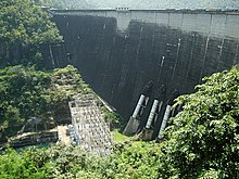
The Bhumibol Dam (formerly known as the Yanhi Dam) is a concrete arch dam on the Ping River, a tributary of the Chao Phraya River, in Sam Ngao District of Tak Province, Thailand. It is about 480 km (298 mi) north of Bangkok and was built for the purposes of water storage, hydroelectric power production, flood control, fisheries and saltwater intrusion management. The dam was named after King Bhumibol Adulyadej and it was Thailand's first multi-purpose project.[1] It is the highest dam in Thailand at 154 m (505 ft) tall.[2][3]
- ^ Cite error: The named reference
EGAT-BDwas invoked but never defined (see the help page). - ^ Philip Hirsch, Carol Warren (31 January 2002). The Politics of Environment in Southeast Asia. Routledge. p. 51. ISBN 9781134690459. Retrieved 2 November 2019.
- ^ Martin Wieland, Qingwen Ren, John S.Y. Tan (14 May 2014). New Developments in Dam Engineering: Proceedings of the 4th International Conference on Dam Engineering, 18–20 October, Nanjing, China. CRC Press. p. 178. ISBN 9780203020678. Retrieved 2 November 2019.
{{cite book}}: CS1 maint: multiple names: authors list (link)
