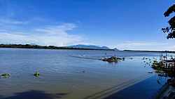
| Bicol River | |
|---|---|
 The Bicol River at Calabanga | |
 Bicol River drainage area | |
Bicol River mouth | |
| Native name | Salog Bikol (Central Bikol) |
| Location | |
| Country | Philippines |
| Region | Bicol Region |
| Province | Camarines Sur |
| Cities | |
| Physical characteristics | |
| Source | Lake Bato |
| • location | Bato, Camarines Sur and Libon, Albay, Bicol Region |
| • coordinates | 13°19′55″N 123°21′32″E / 13.33194°N 123.35889°E |
| • elevation | 6 m (20 ft) |
| Mouth | |
• location | Between Cabusao and Calabanga, Camarines Sur, Bicol Region |
• coordinates | 13°40′18″N 123°06′39″E / 13.67156°N 123.11082°E |
• elevation | 0 m (0 ft) |
| Length | 94 km (58 mi) |
| Basin size | 3,770 km2 (1,460 sq mi) |
| Discharge | |
| • location | San Miguel Bay (when the sea level is low) |
| • average | 165 m3/s (5,800 cu ft/s) |
| • minimum | 123 m3/s (4,300 cu ft/s) |
| • maximum | 205 m3/s (7,200 cu ft/s) |
| Basin features | |
| Tributaries | |
| • left | |
| • right | |
The Bicol River is the eighth largest river in the Philippines in terms of drainage basin size with an estimated catchment area of 3,770 square kilometres (1,460 sq mi). The river drains a large part of Bicol Peninsula of the southeastern part of the island of Luzon and passes through Camarines Sur province.[1]
The river starts from Lake Bato,[1][2] 6 metres (20 ft) above sea level, and flows 94 kilometres (58 mi) downstream to its estuarine mouth at San Miguel Bay. It passes through Naga City, the alluvial and coastal plains of the vast Bicol Valley, an elongated, northwesterly trending depression in the Bicol Region, which contains alluvial plains to the coastal plain. Average slope within the river's drainage basin is 0.006%.
The basin has an influence area of 10,058 square kilometres (3,883 sq mi) including its drainage basin. It lies between 13°0 to 14°N and 123°0 and 124°0 E. It is extensively a coastal flood plain.[2]
- ^ a b "Bicol River Basin and Water Management Project". Regional Development Council - Bicol Region. Archived from the original on September 16, 2008.
- ^ a b Cite error: The named reference
otienowas invoked but never defined (see the help page).

