| Big Hatchet Mountains | |
|---|---|
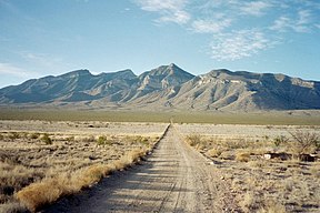
 Big Hatchet Peak at extreme northwest end of range | |
| Highest point | |
| Peak | Big Hatchet Peak-(northwest perimeter of range), Big Hatchet Mountains |
| Elevation | 8,356 ft (2,547 m) |
| Coordinates | 31°38′07″N 108°23′56″W / 31.63528°N 108.39889°W |
| Dimensions | |
| Length | 18 mi (29 km) NW-SE |
| Width | 8 mi (13 km) |
| Geography | |
Big Hatchet Mountains-(Sheridan Wells, range center) in New Mexico | |
| Country | United States |
| State | New Mexico |
| Region(s) | New Mexico Bootheel ((northwest)-Chihuahuan Desert) Continental Divide of the Americas |
| District | Hidalgo County NM |
| Settlement | Hachita, NM |
| Range coordinates | 31°35′50″N 108°20′14″W / 31.59722°N 108.33722°W |
| Borders on | Little Hatchet Mountains-NNW Hatchita Valley-N & NE Playas Valley-NW, W & SW Alamo Hueco Mountains-S |
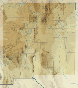
The Big Hatchet Mountains are an 18 mi (29 km) long mountain range in southeast Hidalgo County, New Mexico, adjacent to the northern border of Chihuahua state, Mexico.
The range lies just south of a westerly excursion of the Continental Divide of the Americas; it lies on the eastern perimeter of the extensive, narrow, and north–south Playas Valley, and is the center range of three mostly arid, low to moderate-elevation ranges that lie on the valley's east perimeter. The mountain range lies in the extreme northwest of the Chihuahuan Desert.
