| Big Hole River | |
|---|---|
 Big Hole River near Twin Bridges, Montana | |
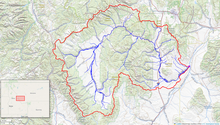
 Map of the Big Hole River watershed | |
| Native name | Sk͏ʷumcné Sewɫk͏ʷs |
| Location | |
| Country | United States |
| State | Montana |
| Physical characteristics | |
| Source | |
| • location | Skinner Lake, Bitterroot Range, Montana, Beaverhead |
| • coordinates | 45°10′22″N 113°30′42″W / 45.17278°N 113.51167°W[1] |
| • elevation | 7,372 ft (2,247 m)[2] |
| Mouth | Jefferson River |
• location | Twin Bridges, Montana |
• coordinates | 45°34′04″N 112°20′21″W / 45.56778°N 112.33917°W[1] |
• elevation | 4,610 ft (1,410 m)[1] |
| Length | 153 mi (246 km) |
| Basin size | 2,800 sq mi (7,300 km2) |
| Discharge | |
| • location | near Twin Bridges |
| • average | 1,250 cu ft/s (35 m3/s)[3] |
| Basin features | |
| Tributaries | |
| • right | Wise River |


The Big Hole River is a tributary of the Jefferson River, approximately 153 miles (246 km) long, in Beaverhead County, in southwestern Montana, United States. It is the last habitat in the contiguous United States for native fluvial Arctic grayling[4] and is a historically popular destination for fly fishing, especially for trout.
- ^ a b c U.S. Geological Survey Geographic Names Information System: Big Hole River
- ^ "Skinner Lake". Geographic Names Information System. United States Geological Survey, United States Department of the Interior.
- ^ "USGS Surface Water data for Montana: USGS Surface-Water Annual Statistics".
- ^ "Arctic Grayling - Endangered Species of the Mountain-Prairie Region". U. S. Fish and Wildlife Service. Retrieved 2014-10-26.
