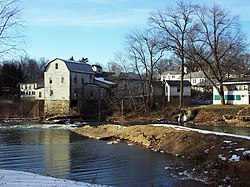
The Big River is a tributary of the Meramec River in east-central Missouri. The river rises in western Iron County near the summit of Johnson Mountain just north of Missouri Route 32 and approximately 3.5 miles southeast of the community of Enough.[2] It flows through Washington, Saint Francois, and Jefferson counties. It forms part of the boundary between Jefferson and Saint Francois counties and also part of the boundary between Jefferson and Washington counties. It empties into the Meramec River opposite Eureka where the Meramec forms the border between Jefferson and Saint Louis counties. The river flows through Washington State Park, St. Francois State Park, and the Lead Belt mining district. The elevation of the river at its source is approximately 1,300 feet (400 m) above sea level and at its mouth about 400 feet (120 m). The length of the river is approximately 145 miles (233 km),[4] while the airline distance between source and mouth is about 56 miles (90 km). Its watershed area is 955 square miles (2,470 km2).
The river flows through or near the communities of Belgrade, Irondale, Park Hills, Bonne Terre, Morse Mill, Cedar Hill, and Byrnes Mill.
Tributaries of the Big River include Flat River, Belews Creek, Turkey Creek, Mill Creek, Mineral Fork, Calico Creek, Heads Creek, Terre Bleue Creek, Ditch Creek, and Jones Creek.
- ^ a b U.S. Geological Survey Geographic Names Information System: Big River (Missouri)
- ^ a b Johnson Mountain, MO, 7.5 Minute Topographic Quadrangle, USGS, 1968 (1977 rev.)
- ^ "USGS Surface Water data for Missouri: USGS Surface-Water Annual Statistics".
- ^ U.S. Geological Survey. National Hydrography Dataset high-resolution flowline data. The National Map Archived 2012-03-29 at the Wayback Machine, accessed May 13, 2011


