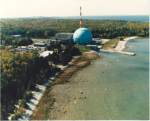
| Big Rock Point Nuclear Power Plant | |
|---|---|
 | |
 | |
| Country |
|
| Location | |
| Coordinates | 45°21′32″N 85°11′50″W / 45.3589°N 85.1972°W |
| Status | Decommissioned |
| Construction began |
|
| Commission date |
|
| Decommission date |
|
| Nuclear power station | |
| Reactor type | |
| Reactor supplier | |
| Thermal capacity |
|
| Power generation | |
| Units decommissioned | 1 × 71 MW |
| Nameplate capacity |
|
| External links | |
| Commons | Related media on Commons |
| Big Rock Point Nuclear Power Plant | |
|---|---|
 Michigan state historic marker | |
| Location | Lake Michigan Shores Roadside Park, U.S. Route 31 Hayes Township, Michigan |
| Coordinates | 45°21′46″N 85°10′32″W / 45.36278°N 85.17556°W |
| Built | 1960–1962 |
| Demolished | 2003 |
| Designated | 2007 |
Big Rock Point was a nuclear power plant near Charlevoix, Michigan, United States. Big Rock operated from 1962 to 1997. It was owned and operated by Consumers Power, now known as Consumers Energy. Its boiling water reactor was made by General Electric (GE) and was capable of producing 67 megawatts of electricity. Bechtel Corporation was the primary contractor.