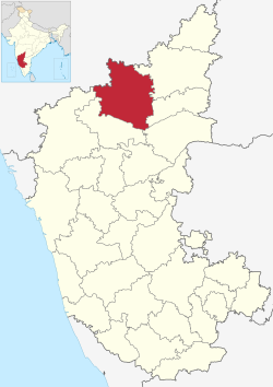
Bijapur district | |
|---|---|
| Vijayapura district | |
 Location in Karnataka | |
| Coordinates: 16°49′N 75°43′E / 16.82°N 75.72°E | |
| Country | |
| State | Karnataka |
| Established | 1 November 1956 |
| Headquarters | Bijapur |
| Talukas | Bijapur, Basavana Bagewadi, Sindagi, Indi, Muddebihal, Nidagundi, Talikote, Babaleshwar, Tikota, Chadchan, Devara Hipparagi, Kolhar, Almel. |
| Government | |
| • Deputy Commissioner | T Bhoobalan (IAS) |
| Area | |
• Total | 10,498 km2 (4,053 sq mi) |
| Population (2011) | |
• Total | 2,177,331 |
| • Density | 210/km2 (540/sq mi) |
| Languages | |
| • Official | Kannada |
| Time zone | UTC+5:30 (IST) |
| Telephone code | + 91 (0) 8352 |
| ISO 3166 code | IN-KA |
| Vehicle registration | |
| Website | vijayapura |
Bijapur district, officially known as Vijayapura district,[1] is a district in the state of Karnataka in India. The city of Bijapur is the headquarters of the district, and is located 530 km northwest of Bangalore. Bijapur is well known for the great monuments of historical importance built during the Adil Shahi dynasty.
- ^ "Bangalore becomes 'Bengaluru'; 11 other cities renamed". The Economic Times. PTI. 1 November 2014. Retrieved 22 October 2023.


