Birnagar | |
|---|---|
City | |
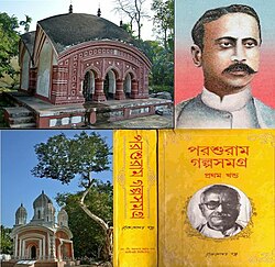
 Temples in Birnagar, Rajshekhar Basu (bottom right) & Nabin Chandra Sen (right) | |
| Coordinates: 23°14′36″N 88°33′30″E / 23.2433°N 88.5582°E | |
| Country | |
| State | West Bengal |
| District | Nadia |
| Government | |
| • Type | Municipality |
| • Body | Birnagar Municipality |
| Area | |
• Total | 6 km2 (2 sq mi) |
| Elevation | 13 m (43 ft) |
| Population (2011) | |
• Total | 32,799 |
| • Density | 5,500/km2 (14,000/sq mi) |
| Languages | |
| • Official | Bengali, English |
| Time zone | UTC+5:30 (IST) |
| Website | www |
Birnagar (formerly known as Ula) is an island municipality situated in the Hooghly River, within the Ranaghat subdivision of Nadia district in West Bengal, India. It traces its origins back to the pre-colonial era when it was established. Prior to the British colonization of India, Birnagar was known as "Ula."
The Birnagar railway station is located 81 kilometers north of Kolkata within the Sealdah railway division.[2]
Birnagar is the oldest municipality in Nadia district, consisting of 14 wards. The first chairman of Birnagar was the renowned poet Nabinchandra Sen.
- ^ "Birnagar City".
- ^ "District Wise List of Statutory Towns". Census of India 2001, Urban Frame. Directorate of Census Operations, West Bengal. Archived from the original on 27 September 2007. Retrieved 6 October 2007.

