| Ward of Bishopsgate | |
|---|---|
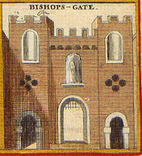
 A c. 1650 print of the gate | |
 Bishopsgate Ward within the city - after the boundary changes of 1994 and 2003 | |
Location within Greater London | |
| Population | 222 (2011 Census Ward)[1] |
| OS grid reference | TQ330813 |
| Sui generis | |
| Administrative area | Greater London |
| Region | |
| Country | England |
| Sovereign state | United Kingdom |
| Post town | LONDON |
| Postcode district | EC2 |
| Dialling code | 020 |
| Police | City of London |
| Fire | London |
| Ambulance | London |
| UK Parliament | |
| London Assembly | |
Bishopsgate was one of the eastern gates in London's former defensive wall. The gate's name is traditionally attributed to Earconwald, who was Bishop of London in the 7th century. It was first built in Roman times and marked the beginning of Ermine Street, the ancient road running from London to York (Eboracum). The gate was rebuilt twice in the 15th and 18th centuries, but was permanently demolished in 1760.
Bishopsgate gave its name to the Bishopsgate Ward of the City of London. The ward is traditionally divided into Bishopsgate Within, inside the line of the former wall, and Bishopsgate Without beyond it. Bishopsgate Without is described as part of London's East End.[2] The ancient boundaries of the City wards were reviewed in 1994 and 2013, so that the wards no longer correspond very closely to their historic extents. Bishopsgate Without gained a significant part of Shoreditch from the London Borough of Hackney, while nearly all of Bishopsgate Within was transferred to other wards.
Bishopsgate is also the name of the street, being the part of the originally Roman Ermine Street (now the A10) within the traditional extent of the Ward.
- ^ "City of London ward population 2011". Neighbourhood Statistics. Office for National Statistics. Archived from the original on 8 April 2017. Retrieved 16 October 2016.
- ^ Beyond the Tower: a history of East London. by John Marriot. In it refers back to 18th century descriptions of Bishopsgate Without and Shoreditch as EE districts
