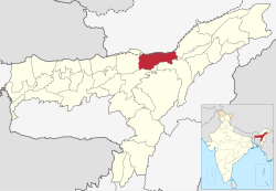
Biswanath District | |
|---|---|
 Vasudeva Doul | |
 Location in Assam | |
| Country | |
| State | Assam |
| Division | North Assam |
| Incorporated (District) | 15 August 2015 |
| Headquarter | Biswanath Chariali |
| Government | |
| • Lok Sabha constituencies | Tezpur |
| • Vidhan Sabha constituencies | Biswanath, Behali, Gohpur |
| Area | |
• Total | 1,415 km2 (546 sq mi) |
| Elevation | 48−849 m (157−2,787 ft) |
| Population (2011) | |
• Total | 612,491 |
| • Density | 430/km2 (1,100/sq mi) |
| Languages | |
| • Official | Assamese |
| Time zone | UTC+5:30 (IST) |
| Vehicle registration | AS-32 |
| Website | biswanath.gov.in |
Biswanath (IPA: ˌbɪswəˈnɑːθ ˈtʃɑːrɪˌælɪ) is an administrative district in the state of Assam in India. It is one of newly created district in the year by 2015, declared by Assam Chief Minister Tarun Gogoi on 15 August 2015.[1][2]
The district is created amalgamating Gohpur and most part of Biswanath Sub division on earlier Sonitpur district. The district is bounded by Arunachal Pradesh on north, Golaghat, Brahmaputra River on the south, Lakhimpur district on the east and Sonitpur district on the west. The administrative headquarter is located at Biswanath Chariali.
On 31 December 2022, the district remerged with existing Sonitpur district ahead of delimitation process by ECI in the state.[3]
However, on August 25, 2023, the Assam cabinet announced the restoration of Biswanath's district status.[4]
- ^ "CM Tarun Gogoi announces 5 new districts in Assam on Independence Day". Archived from the original on 2016-03-03. Retrieved 2016-01-27.
- ^ "Assam gets five more districts". 15 August 2015. Archived from the original on 25 April 2019. Retrieved 27 January 2016.
- ^ Tribune, The Assam (2022-12-31). "Assam: Four districts to re-merge with existing districts". assamtribune.com. Archived from the original on 2023-01-03. Retrieved 2023-01-03.
- ^ "Assam Cabinet decides to 'create' 4 districts". The Hindu. 25 August 2023. Archived from the original on 26 August 2023. Retrieved 26 August 2023.
