| |
|---|---|
Village | |
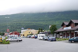
 View of Bjerkvik | |
 | |
| Coordinates: 68°32′57″N 17°33′26″E / 68.5492°N 17.5571°E | |
| Country | Norway |
| Region | Northern Norway |
| County | Nordland |
| District | Ofoten |
| Municipality | Narvik Municipality |
| Area | |
| • Total | 1.34 km2 (0.52 sq mi) |
| Elevation | 6 m (20 ft) |
| Population (2023)[1] | |
| • Total | 1,088 |
| • Density | 812/km2 (2,100/sq mi) |
| Time zone | UTC+01:00 (CET) |
| • Summer (DST) | UTC+02:00 (CEST) |
| Post Code | 8530 Bjerkvik |
Bjerkvik (Norwegian) or Rahkka (Northern Sami)[3] is a village in Narvik Municipality in Nordland county, Norway. The village is located at the end of Herjangsfjorden, an arm of Ofotfjorden. Bjerkvik sits less than 20 kilometres (12 mi) south of the border of Troms county and about 13 kilometres (8.1 mi) across the fjord from the town of Narvik. The 1.34-square-kilometre (330-acre) village has a population (2023) of 1,088 and a population density of 812 inhabitants per square kilometre (2,100/sq mi).[1]
The European route E6 and European route E10 highways meet in Bjerkvik, a central location on the roads connecting Harstad, Narvik, and Tromsø. Elvegårdsmoen military camp lies on the eastern edge of the village near the lake Hartvikvatnet.[4]
Bjerkvik School is an elementary and secondary school in Bjerkvik. The school has about 200 pupils. The village also has two gas stations and three grocery stores. Bjerkvik Church was built here in 1955 to serve the northern part of the municipality.
- ^ a b c Statistisk sentralbyrå (2023-12-23). "Urban settlements. Population and area, by municipality".
- ^ "Bjerkvik, Narvik (Nordland)". yr.no. Retrieved 2019-01-07.
- ^ "Informasjon om stadnamn". Norgeskart (in Norwegian). Kartverket. Retrieved 2024-08-26.
- ^ Store norske leksikon. "Bjerkvik" (in Norwegian). Retrieved 2012-05-29.

