This article needs additional citations for verification. (September 2022) |
Blachownia | |
|---|---|
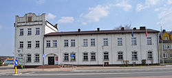
 Town hall | |
| Coordinates: 50°47′N 18°58′E / 50.783°N 18.967°E | |
| Country | |
| Voivodeship | Silesian |
| County | Częstochowa |
| Gmina | Blachownia |
| Established | 17th century |
| Town rights | 1967 |
| Government | |
| • Mayor | Cezary Osiński |
| Area | |
• Total | 36.66 km2 (14.15 sq mi) |
| Population | |
• Total | 9,383 |
| • Density | 256/km2 (660/sq mi) |
| Time zone | UTC+1 (CET) |
| • Summer (DST) | UTC+2 (CEST) |
| Postal code | 42-290 |
| Area code | +48 34 |
| Climate | Cfb |
| Car plates | SCZ |
| National roads | |
| Voivodeship roads | |
| Website | http://blachownia.pl/ |
Blachownia [blaˈxɔvɲa] is a town in Częstochowa County, Silesian Voivodeship, Poland. It lies about 10 km (6.2 mi) west of the city of Częstochowa. The town belongs to historic Lesser Poland. As of December 2021, it has a population of 9,383.[3]
- ^ "Burmistrz Blachowni". blachownia.pl (in Polish). Gmina Blachownia. Retrieved 12 September 2022.
- ^ "Local Data Bank". bdl.stat.gov.pl. Statistics Poland. Retrieved 12 September 2022. Category K1, group G441, subgroup P1410. Data for territorial unit 2404014.
- ^ a b "Local Data Bank". bdl.stat.gov.pl. Statistics Poland. Retrieved 12 September 2022. Category K3, group G7, subgroup P1336. Data for territorial unit 2404014.
- ^ "Local Data Bank". bdl.stat.gov.pl. Statistics Poland. Retrieved 12 September 2022. Category K3, group G7, subgroup P2425. Data for territorial unit 2404014.


