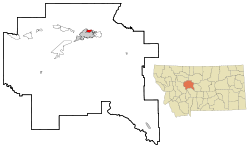
Black Eagle, Montana | |
|---|---|
 Location of Black Eagle, Montana | |
| Coordinates: 47°31′35″N 111°16′42″W / 47.52639°N 111.27833°W | |
| Country | United States |
| State | Montana |
| County | Cascade |
| Area | |
• Total | 1.73 sq mi (4.48 km2) |
| • Land | 1.54 sq mi (3.99 km2) |
| • Water | 0.19 sq mi (0.49 km2) |
| Elevation | 3,379 ft (1,030 m) |
| Population (2020) | |
• Total | 949 |
| • Density | 615.83/sq mi (237.71/km2) |
| Time zone | UTC-7 (Mountain (MST)) |
| • Summer (DST) | UTC-6 (MDT) |
| ZIP code | 59414 |
| Area code | 406 |
| FIPS code | 30-07150 |
| GNIS feature ID | 0802039 |
Black Eagle is a census-designated place (CDP) in Cascade County, Montana, United States. The population was 904 at the 2010 census.[2] It is a suburb of Great Falls.
- ^ "ArcGIS REST Services Directory". United States Census Bureau. Retrieved September 5, 2022.
- ^ "Profile of General Population and Housing Characteristics: 2010 Demographic Profile Data (DP-1): Black Eagle CDP, Montana". United States Census Bureau. Retrieved January 26, 2012.