Black Forest, Colorado | |
|---|---|
 The Black Forest School | |
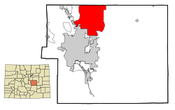
 Location of the Black Forest CDP in El Paso County, Colorado | |
| Coordinates: 39°03′39″N 104°40′31″W / 39.06083°N 104.67528°W[1] | |
| Country | |
| State | |
| County | El Paso County |
| Government | |
| • Type | unincorporated community |
| Area | |
| • Total | 260.807 km2 (100.698 sq mi) |
| • Land | 260.657 km2 (100.640 sq mi) |
| • Water | 0.150 km2 (0.058 sq mi) |
| Elevation | 2,308 m (7,573 ft) |
| Population | |
| • Total | 15,097 |
| • Density | 58/km2 (150/sq mi) |
| Time zone | UTC-7 (MST) |
| • Summer (DST) | UTC-6 (MDT) |
| ZIP Code[3] | Colorado Springs 80908 and Elbert 80106 |
| Area code | 719 |
| GNIS feature ID | 2407856[1] |
Black Forest is an unincorporated community and a census-designated place (CDP) located in and governed by El Paso County, Colorado, United States. The CDP is a part of the Colorado Springs, CO Metropolitan Statistical Area. The population of the Black Forest CDP was 15,097 at the United States Census 2020.[2] Both the Colorado Springs post office (Zip Code 80908) and the Elbert post office (Zip Code 80106) serve the area.[3]
The Black Forest is named for a dense stand of Ponderosa Pine in the area. In 2006, residents voted against a proposal to incorporate as a city.
- ^ a b c d U.S. Geological Survey Geographic Names Information System: Black Forest, Colorado
- ^ a b c "State of Colorado Census Designated Places - BAS20 - Data as of January 1, 2020". United States Census Bureau. Retrieved November 3, 2021.
- ^ a b "Look Up a ZIP Code". United States Postal Service. Retrieved December 5, 2020.
