| Black River | |
|---|---|
 The Black River's Great Falls, Watertown, New York | |
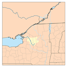
 A map of the Black River watershed | |
| Location | |
| Country | United States |
| State | New York |
| Physical characteristics | |
| Source | North Lake |
| • location | Herkimer County, New York, Adirondack Mountains |
| • coordinates | 43°31′19″N 74°56′53″W / 43.52194°N 74.94806°W[1] |
| • elevation | 1,850 ft (560 m) |
| Mouth | Lake Ontario |
• location | Dexter, Jefferson County |
• coordinates | 43°59′39″N 76°03′54″W / 43.99417°N 76.06500°W[1] |
• elevation | 246 ft (75 m) |
| Length | 125 mi (201 km) |
| Basin size | 1,920 sq mi (5,000 km2)[2] |
| Discharge | |
| • location | Watertown[3] |
| • average | 4,242 cu ft/s (120.1 m3/s)[3] |
| • minimum | 137 cu ft/s (3.9 m3/s) |
| • maximum | 52,000 cu ft/s (1,500 m3/s) |
| Basin features | |
| Progression | Lake Ontario→ Saint Lawrence River→ Gulf of Saint Lawrence |
| River system | Lake Ontario drainage basin |
| Tributaries | |
| • left | South Branch Black River, Deer River |
| • right | Moose River Otter Creek, Independence River, Beaver River |
The Black River is a 125-mile-long (201 km)[4] blackwater river that empties into the eastern end of Lake Ontario on the shore of Jefferson County, New York in the United States. The origin of the name is not clear, but it may stem from the natural tannic acid that darkens the water in places. The river flows in a generally northwest direction, with its valley dividing the Adirondack Mountains on the east from the Tug Hill region to the west.
- ^ a b "Black River". Geographic Names Information System. United States Geological Survey, United States Department of the Interior. 1980-01-23. Retrieved 2014-11-04.
- ^ NYS Department of Environmental Conservation. "Black River Watershed". Dec.ny.gov. Archived from the original on February 27, 2015. Retrieved March 15, 2015.
- ^ a b U.S. Geological Survey (2014). SITE 04260500 BLACK RIVER AT WATERTOWN NY (PDF). U.S. Geological Survey Water-Data Report 2013 (Report). p. 3. Archived (PDF) from the original on November 5, 2014. Retrieved March 15, 2015.
- ^ "The National Map". U.S. Geological Survey. Archived from the original on 2012-03-29. Retrieved Feb 14, 2011.