| Blanchard River | |
|---|---|
 The Blanchard River in Findlay | |
| Physical characteristics | |
| Source | |
| • location | ~ 5 mi (8.0 km) northwest of Kenton |
| Mouth | |
• location | Auglaize River near Dupont |
• elevation | 686 ft (209 m)[1] |
| Length | 103 mi (166 km) |
| Basin size | 771 sq mi (2,000 km2)[2] |

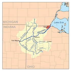
The Blanchard River is a 103-mile-long (166 km)[3] tributary of the Auglaize River in northwestern Ohio in the United States. It drains a primarily rural farming area in the watershed of Lake Erie. Much of the length of the river can be navigated by canoe.[4]
It rises in central Hardin County, on the northern outskirts of Kenton. It flows generally north for its first 25 miles (40 km) into eastern Hancock County, where it turns sharply to the west. It flows west through Findlay and past Ottawa. It joins the Auglaize from the east in western Putnam County approximately 2 miles (3 km) north of Cloverdale at 41°02′29″N 84°17′57″W / 41.041483°N 84.299245°W.
- ^ U.S. Geological Survey Geographic Names Information System: Blanchard River
- ^ "Map of Ohio watersheds". Archived from the original on 2007-03-11.
- ^ U.S. Geological Survey. National Hydrography Dataset high-resolution flowline data. The National Map Archived 2012-03-29 at the Wayback Machine, accessed May 19, 2011
- ^ "Blanchard River Water Trail" (PDF). ohiodnr.gov. ODNR. Retrieved 24 January 2024.