Blatnica | |
|---|---|
Village | |
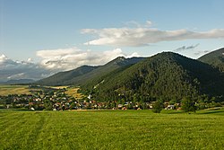
 Blatnica on the foot of the Greater Fatra Range | |
| Coordinates: 48°56′13″N 18°55′36″E / 48.93694°N 18.92667°E | |
| Country | Slovakia |
| Region | Žilina |
| District | Martin |
| Area | |
| • Total | 86.186 km2 (33.277 sq mi) |
| Elevation | 500 m (1,600 ft) |
| Population (2005-12-31) | |
| • Total | 881 |
| • Density | 10/km2 (26/sq mi) |
| Postal code | 038 15 |
| Area code | +421-43 |
| Car plate | MT |
| Website | www.gader.sk |
Blatnica (1927–1946 Turčianska Blatnica, Hungarian: Blatnica) is a village and municipality in the Turiec region of Slovakia. Administratively it is a part of the Martin District in the Žilina Region. The village is situated under the Greater Fatra Range, at the opening of the spectacular karst Gader and Blatnica valleys. The ruins of the Blatnica Castle lie on a low ridge over the village.
