Blijham | |
|---|---|
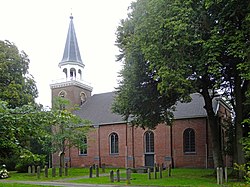
 Dutch Reformed Church of Blijham in 2015 | |
Location in the province of Groningen in the Netherlands | |
| Coordinates: 53°6′35″N 7°4′35″E / 53.10972°N 7.07639°E | |
| Country | Netherlands |
| Province | Groningen |
| Municipality | Westerwolde |
| Area (2012)[1] | |
| • Total | 237 ha (586 acres) |
| • Land | 235 ha (581 acres) |
| • Water | 2 ha (5 acres) |
| Population (2017)[1] | |
| • Total | 2,240 |
| • Density | 950/km2 (2,400/sq mi) |
| Postal code | 9697[2] |
| Area code | 0597[3] |
Blijham (Dutch pronunciation: [blɛiˈɦɑm]) is a village with a population of 2,240 in the municipality of Westerwolde in the province of Groningen in the Netherlands. The origins of the settlement date back to the 11th century. Until 1968, Blijham was part of the municipality of Wedde. Until 2017, it was part of the municipality of Bellingwedde.
- ^ a b (in Dutch) Kerncijfers wijken en buurten, Statistics Netherlands, 2017. Retrieved on 2 December 2017.
- ^ (in Dutch) Resultaten voor "Blijham,", Postcode.nl. Retrieved on 19 January 2014.
- ^ (in Dutch) Netnummer zoeken, Telefoonboek.nl. Retrieved on 19 January 2014.

