Bloomfield, Missouri | |
|---|---|
 Stoddard County Courthouse, February 2014 | |
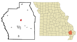
 Location of Bloomfield, Missouri | |
| Coordinates: 36°53′15″N 89°55′50″W / 36.88750°N 89.93056°W[1] | |
| Country | United States |
| State | Missouri |
| County | Stoddard |
| Government | |
| • Type | Mayor-Council |
| • Mayor | Bill Aslin |
| Area | |
| • Total | 1.23 sq mi (3.19 km2) |
| • Land | 1.23 sq mi (3.19 km2) |
| • Water | 0.00 sq mi (0.00 km2) |
| Elevation | 453 ft (138 m) |
| Population (2020) | |
| • Total | 1,755 |
| • Density | 1,424.51/sq mi (549.81/km2) |
| Time zone | UTC-6 (Central (CST)) |
| • Summer (DST) | UTC-5 (CDT) |
| ZIP code | 63825 |
| Area code | 573 |
| FIPS code | 29-06382[3] |
| GNIS feature ID | 2394194[1] |
Bloomfield is a city in Stoddard County, Missouri, United States. The population was 1,755 at the 2020 census.[4] It is the county seat of Stoddard County.[5] In September 1864 during the Civil War, the town was reduced to ashes.
- ^ a b c U.S. Geological Survey Geographic Names Information System: Bloomfield, Missouri
- ^ "ArcGIS REST Services Directory". United States Census Bureau. Retrieved August 28, 2022.
- ^ "U.S. Census website". United States Census Bureau. Retrieved January 31, 2008.
- ^ "Bloomfield city, Missouri - Census Bureau Profile". United States Census Bureau. Retrieved March 1, 2024.
- ^ "Find a County". National Association of Counties. Archived from the original on May 31, 2011. Retrieved June 7, 2011.