Bloomfield Township, Crawford County, Pennsylvania | |
|---|---|
 | |
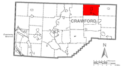
 Location of Bloomfield Township in Crawford County | |
 Location of Crawford County in Pennsylvania | |
| Country | United States |
| State | Pennsylvania |
| County | Crawford County |
| Area | |
| • Total | 38.24 sq mi (99.04 km2) |
| • Land | 37.91 sq mi (98.20 km2) |
| • Water | 0.33 sq mi (0.85 km2) |
| Highest elevation [2] (Shreve Ridge near Crawford-Erie County line) | 1,710 ft (520 m) |
| Lowest elevation [2] (Oil Creek at Township line near Riceville, Pennsylvania) | 1,310 ft (400 m) |
| Population (2020) | |
| • Total | 1,861 |
| • Estimate (2023)[3] | 1,829 |
| • Density | 49.09/sq mi (18.95/km2) |
| Time zone | UTC-4 (EST) |
| • Summer (DST) | UTC-5 (EDT) |
| Area code | 814 |
Bloomfield Township is a township in Crawford County, Pennsylvania, United States. The population was 1,861 at the 2020 census.[3]
- ^ "2016 U.S. Gazetteer Files". United States Census Bureau. Retrieved August 13, 2017.
- ^ a b "Canadohta Lake Topo Map, Crawford County PA (Lake Canadohta Area)". TopoZone. Locality, LLC. Retrieved September 1, 2019.
- ^ a b Bureau, US Census. "City and Town Population Totals: 2020-2023". Census.gov. US Census Bureau. Retrieved May 18, 2024.
{{cite web}}:|last1=has generic name (help)