Bloomingdale, Michigan | |
|---|---|
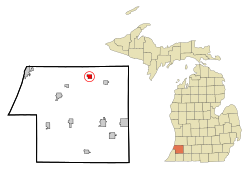
 Location of Bloomingdale within Van Buren County, Michigan | |
| Coordinates: 42°23′0″N 85°57′33″W / 42.38333°N 85.95917°W | |
| Country | United States |
| State | Michigan |
| County | Van Buren |
| Area | |
| • Total | 1.16 sq mi (3.01 km2) |
| • Land | 1.14 sq mi (2.94 km2) |
| • Water | 0.03 sq mi (0.07 km2) |
| Elevation | 732 ft (223 m) |
| Population (2020) | |
| • Total | 513 |
| • Density | 451.98/sq mi (174.44/km2) |
| Time zone | UTC-5 (Eastern (EST)) |
| • Summer (DST) | UTC-4 (EDT) |
| ZIP code | 49026 |
| Area code | 269 |
| FIPS code | 26-09220[2] |
| GNIS feature ID | 2398139[3] |
Bloomingdale is a village in Van Buren County in the U.S. state of Michigan. The population was 454 at the 2010 census. The village is located within Bloomingdale Township and is the township seat.
In the 1930s oil was discovered within the village limits, but pumping has now ceased due to lack of oil. Bloomingdale was thought to be a rising city but when the oil ceased so did the attraction.
Bloomingdale is considered the midpoint on the Kal-Haven Trail, which runs directly through the main four corners and business district. The downtown Augustus Haven Park with its Depot Museum is a picnic stop for trail users.
- ^ "2020 U.S. Gazetteer Files". United States Census Bureau. Retrieved May 21, 2022.
- ^ "U.S. Census website". United States Census Bureau. Retrieved January 31, 2008.
- ^ U.S. Geological Survey Geographic Names Information System: Bloomingdale, Michigan