| Blue Bell Hill | |
|---|---|
 | |
 | |
| Type | Nature reserve |
| Location | Aylesford, Kent |
| OS grid | TQ743621 |
| Area | 5 hectares (12 acres) |
| Managed by | Kent Wildlife Trust |
| Blue Bell Hill | |
|---|---|
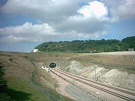
 The High Speed 1 tunnel portal, under the North Downs at Blue Bell Hill | |
| Highest point | |
| Elevation | 160 m (520 ft) |
| Prominence | c. 30 m |
| Geography | |
 | |
| Location | North Downs, England |
| OS grid | TQ740625 |
| Topo map | OS Landranger 188 |
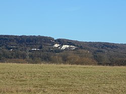
Blue Bell Hill is a chalk hill between Maidstone and Rochester in the English county of Kent. It overlooks the River Medway and is part of the North Downs. Settlements on the hill include the Walderslade suburb of Chatham and the villages of Blue Bell Hill and Kit's Coty. During the eighteenth and nineteenth centuries much of the hill was quarried for chalk.[1]
The hill is a 5-hectare (12-acre) nature reserve which is managed by Kent Wildlife Trust.[2] It is also part of the Kent Downs Area of Outstanding Natural Beauty[3] and Wouldham to Detling Escarpment Sites of Special Scientific Interest[4] and is a Nature Conservation Review site, Grade I.[5]
A picnic area serves as a rest point for walkers on the North Downs Way which runs along the top of the hill, whilst the prehistoric trackway of the Pilgrims' Way skirts its foot. A modern crematorium also surmounts the hill.
The A229 dual carriageway follows the route of a former Roman road and climbs the hill, today linking the M2 and M20 motorways. High Speed 1 runs beneath the hill, via the North Downs Tunnel, and archaeological work in advance of it uncovered a Neolithic long house on its slopes. The Bluebell Hill transmitting station is on the hill,[6] as is the Lower Bell pub.[7] The Upper Bell pub was closed around March 2005 due to the reduced demand caused by the closure of a slip-lane onto the southbound A229, and then demolished in 2013.[8]
- ^ Panoramic view from the hill Archived 10 December 2004 at the Wayback Machine
- ^ "Blue Bell Hill". Kent Wildlife Trust. Archived from the original on 3 January 2018. Retrieved 8 March 2018.
- ^ "Blue Bell Hill Picnic Site". Kent Downs AONB. Archived from the original on 17 March 2018. Retrieved 8 March 2018.
- ^ "Designated Sites View: Wouldham to Detling Escarpment". Sites of Special Scientific Interest. Natural England. Retrieved 15 January 2018.
- ^ Ratcliffe, Derek, ed. (1977). A Nature Conservation Review. Vol. 2. Cambridge, UK: Cambridge University Press. p. 118. ISBN 0521 21403 3.
- ^ "Bluebell Hill". UK Free TV. Retrieved 14 February 2018.
- ^ "History". Blue Bell Hill Trust. Archived from the original on 20 May 2017. Retrieved 14 February 2018.
- ^ https://www.kentonline.co.uk/medway/news/the-lost-pubs-of-medway-272584/