Town of Bluefield, Virginia | |
|---|---|
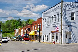
 Virginia Avenue (US 19) | |
| Nickname: Virginia's Tallest Town | |
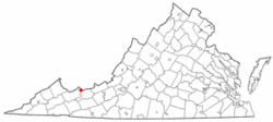
 Location in the Commonwealth of Virginia | |
| Coordinates: 37°14′39″N 81°16′30″W / 37.24417°N 81.27500°W | |
| Country | United States |
| State | Virginia |
| County | Tazewell |
| Founded | 1860s |
| Incorporated | 1883 |
| Government | |
| • Mayor | Donnie Linkous |
| Area | |
• Town | 9.50 sq mi (24.60 km2) |
| • Land | 9.49 sq mi (24.59 km2) |
| • Water | 0.01 sq mi (0.01 km2) |
| Elevation | 2,369 ft (722 m) |
| Population (2020) | |
• Town | 5,096 |
| • Density | 537/sq mi (207.2/km2) |
| • Metro | 106,363 (Bluefield Micropolitan Area) |
| Time zone | UTC−5 (EST) |
| • Summer (DST) | UTC−4 (EDT) |
| ZIP code | 24605 |
| Area code | 276 |
| FIPS code | 51-08152[3] |
| GNIS feature ID | 1481874[2] |
| Website | http://www.bluefieldva.org/ |
Bluefield is a town in Tazewell County, Virginia, United States, located along the Bluestone River. The population was 5,096 at the 2020 census.[4] It is part of the Bluefield WV-VA micropolitan area which has a population of 106,363 in 2020.
- ^ "2019 U.S. Gazetteer Files". United States Census Bureau. Retrieved August 7, 2020.
- ^ a b U.S. Geological Survey Geographic Names Information System: Bluefield, Virginia
- ^ Cite error: The named reference
GR2was invoked but never defined (see the help page). - ^ "Census - Geography Profile: Bluefield town, Virginia". United States Census Bureau. Retrieved February 9, 2022.
