Boca Raton Airport | |||||||||||
|---|---|---|---|---|---|---|---|---|---|---|---|
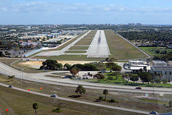
 Runway 5 on final approach | |||||||||||
| Summary | |||||||||||
| Airport type | Public | ||||||||||
| Owner | State of Florida | ||||||||||
| Operator | Boca Raton Airport Authority | ||||||||||
| Serves | Greater Miami | ||||||||||
| Elevation AMSL | 13 ft / 4 m | ||||||||||
| Coordinates | 26°22′43″N 080°06′28″W / 26.37861°N 80.10778°W | ||||||||||
| Website | www | ||||||||||
| Maps | |||||||||||
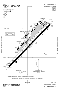
 FAA airport diagram | |||||||||||
 | |||||||||||
| Runways | |||||||||||
| |||||||||||
| Statistics (2018) | |||||||||||
| |||||||||||
Boca Raton Airport (IATA: BCT, ICAO: KBCT, FAA LID: BCT) is a state-owned public-use airport located two miles (3 km) northwest of the central business district of Boca Raton, a city in Palm Beach County, Florida, United States.[1] The airport is immediately adjacent to Florida Atlantic University and to Interstate 95.[2]
Boca Raton Airport is publicly owned and is designated as a general aviation transport facility governed by a seven-member Authority appointed by the City of Boca Raton and Palm Beach County Commission.[2]
- ^ a b FAA Airport Form 5010 for BCT PDF, effective December 31, 2020
- ^ a b Boca Raton Airport Authority URL retrieved April 5, 2006