Bodie | |
|---|---|
 County Barn, Bodie, California | |
| Coordinates: 38°12′44″N 119°00′44″W / 38.21222°N 119.01222°W | |
| Country | United States |
| State | California |
| County | Mono |
| Founded | 1876 |
| Elevation | 8,379 ft (2,554 m) |
| Population | |
| • Total | 11 |
| Time zone | UTC−8 (Pacific) |
| • Summer (DST) | UTC−7 (PDT) |
| Area codes | 442/760 |
| Climate | Dsc |
| Website | Bodie State Historic Park |
Bodie Historic District | |
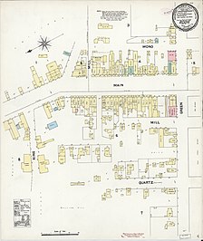
 Map of Bodie, as of 1890 | |
| Location | California |
| Nearest city | Bridgeport, California |
| Architectural style | Various; Southwestern U.S. frontier-style, late-19th to early-20th century. |
| NRHP reference No. | 66000213 |
| CHISL No. | 341[3] |
| Significant dates | |
| Added to NRHP | October 15, 1966[4] |
| Designated NHLD | July 4, 1961[5] |
Bodie (/ˈboʊdiː/ BOH-dee) is a ghost town in the Bodie Hills east of the Sierra Nevada mountain range in Mono County, California, United States. It is about 75 miles (121 km) southeast of Lake Tahoe, and 12 mi (19 km) east-southeast of Bridgeport,[6] at an elevation of 8,379 feet (2554 m).[1] Bodie became a boom town in 1876 after the discovery of a profitable vein of gold; by 1879 it had established 2,000 structures with a population of roughly 8,000 people.[7]
The town went into decline in the subsequent decades and came to be described as a ghost town by 1915. The U.S. Department of the Interior recognizes the designated Bodie Historic District as a National Historic Landmark.
Also registered as a California Historical Landmark,[3] the ghost town officially was established as Bodie State Historic Park in 1962. It receives about 200,000 visitors yearly.[8] Bodie State Historic Park is partly supported by the Bodie Foundation.[9]
- ^ a b U.S. Geological Survey Geographic Names Information System: Bodie
- ^ "Mono County, California". 2020: DEC Redistricting Data (PL 94-171). US Census Bureau. Retrieved November 6, 2021.
- ^ a b "Bodie". Office of Historic Preservation, California State Parks. Retrieved October 10, 2012.
- ^ "National Register Information System". National Register of Historic Places. National Park Service. April 15, 2008.
- ^ "Bodie Historic District". National Historic Landmark summary listing. National Park Service. Archived from the original on December 1, 2007. Retrieved June 16, 2008.
- ^ Durham, David L. (1998). California's Geographic Names: A Gazetteer of Historic and Modern Names of the State. Clovis, Calif.: Word Dancer Press. ISBN 1-884995-14-4.
- ^ "Bodie SHP". CA State Parks. Retrieved September 7, 2023.
- ^ DeLyser, Dydia (December 1999). "Authenticity on the Ground: Engaging the Past in a California Ghost Town". Annals of the Association of American Geographers. 89 (4). Association of American Geographers: 602. doi:10.1111/0004-5608.00164.
- ^ "Bodie State Historic Park" (PDF). California State Parks. Retrieved March 10, 2020.

