This article needs additional citations for verification. (January 2017) |
Bogny-sur-Meuse | |
|---|---|
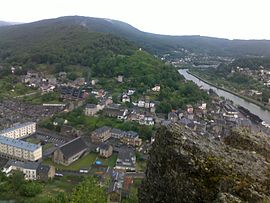
 View of the town | |
| Coordinates: 49°51′03″N 4°46′04″E / 49.8508°N 4.7678°E | |
| Country | France |
| Region | Grand Est |
| Department | Ardennes |
| Arrondissement | Charleville-Mézières |
| Canton | Bogny-sur-Meuse |
| Intercommunality | Vallées et Plateau d'Ardenne |
| Government | |
| • Mayor (2020–2026) | Kevin Gengoux[1] |
Area 1 | 23.16 km2 (8.94 sq mi) |
| Population (2021)[2] | 5,006 |
| • Density | 220/km2 (560/sq mi) |
| Time zone | UTC+01:00 (CET) |
| • Summer (DST) | UTC+02:00 (CEST) |
| INSEE/Postal code | 08081 /08120 |
| Elevation | 165 m (541 ft) |
| 1 French Land Register data, which excludes lakes, ponds, glaciers > 1 km2 (0.386 sq mi or 247 acres) and river estuaries. | |
Bogny-sur-Meuse (French pronunciation: [bɔɲi syʁ møz], literally Bogny on Meuse) is a commune in the Ardennes department in the Grand Est region of northern France. Bogny-sur-Meuse is known for multiple sites linked to the medieval legend of The Four Sons of Aymon, such as the Hermitage, the statue of Bayard the horse, and the four peaks symbolizing the four brothers. Situated in the Ardennes mountains, the commune extends along the banks of the Meuse.
- ^ "Répertoire national des élus: les maires" (in French). data.gouv.fr, Plateforme ouverte des données publiques françaises. 13 September 2022.
- ^ "Populations légales 2021" (in French). The National Institute of Statistics and Economic Studies. 28 December 2023.


