| Bogong High Plains | |
|---|---|
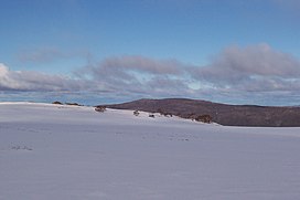
 Typical winter scene | |
| Highest point | |
| Peak | Mount Nelse West, Alpine National Park |
| Elevation | 1,893 m (6,211 ft)[1] AHD |
| Coordinates | 36°50′39″S 147°20′24″E / 36.84417°S 147.34000°E[1] |
| Geography | |
Location of the Bogong High Plains in Victoria | |
| Country | Australia |
| Region | Victoria |
| Parent range | Victorian Alps, Great Dividing Range |
| Geology | |
| Rock age | Devonian |
| Rock types | |
The Bogong High Plains (/ˈboʊɡɒŋ/), part of the Victorian Alps of the Great Dividing Range, are a section of plains located in the Alpine National Park in the Australian state of Victoria and are situated south of Mount Bogong.
In winter this area is one of the largest snow-covered areas in Australia and can be easily accessed from the Hotham Alpine Resort and Falls Creek ski resort.[2] The area is very popular for both summer and winter time activities. Ski touring and all types of cross-country skiing are possible through most winter months. A trail called Australian Alps Walking Track is popular for hiking in summer and cross-country skiing in winter. Mountain biking and bushwalking are common in summer.[3] Local towns and villages provide the best possibility for exploring the areas, including Mount Beauty and Harrietville.
- ^ a b "Mount Nelse West, Australia". Peakbagger.com.
- ^ "Victoria's seven alpine resorts". www.visitvictoria.com. Archived from the original on 9 September 2007. Retrieved 5 September 2007.
- ^ "Alpine National Park". Parks Victoria. Archived from the original on 6 February 2007. Retrieved 21 January 2007.
