Boiling Springs, North Carolina | |
|---|---|
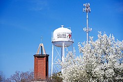
 Water tower in Boiling Springs | |
| Motto: "Crossroads of Opportunity" | |
 Location of Boiling Springs, North Carolina | |
| Coordinates: 35°15′07″N 81°39′49″W / 35.25194°N 81.66361°W | |
| Country | United States |
| State | North Carolina |
| County | Cleveland |
| Area | |
| • Total | 4.48 sq mi (11.60 km2) |
| • Land | 4.48 sq mi (11.60 km2) |
| • Water | 0.00 sq mi (0.00 km2) |
| Elevation | 856 ft (261 m) |
| Population (2020) | |
| • Total | 4,615 |
| • Density | 1,029.90/sq mi (397.69/km2) |
| Time zone | UTC-5 (Eastern (EST)) |
| • Summer (DST) | UTC-4 (EDT) |
| ZIP code | 28017 |
| Area code | 704 |
| FIPS code | 37-06800[3] |
| GNIS feature ID | 2405296[2] |
| Website | boilingspringsnc |
Boiling Springs is a town in Cleveland County, North Carolina, United States and is located in the westernmost part of the Charlotte metropolitan area, located approximately 50 miles away from the city. As of the 2010 census, the town's population was 4,647.[4] It is home to Gardner–Webb University. The town is named after the natural spring found on the university's property, which feeds a small lake.
- ^ "ArcGIS REST Services Directory". United States Census Bureau. Retrieved September 20, 2022.
- ^ a b U.S. Geological Survey Geographic Names Information System: Boiling Springs, North Carolina
- ^ "U.S. Census website". United States Census Bureau. Retrieved January 31, 2008.
- ^ "Geographic Identifiers: 2010 Demographic Profile Data (G001): Boiling Springs town, North Carolina". U.S. Census Bureau, American Factfinder. Archived from the original on February 12, 2020. Retrieved December 31, 2014.