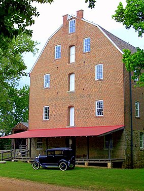
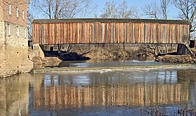
| Bollinger Mill State Historic Site | |
|---|---|
 | |
| Location | Burfordville, Cape Girardeau County, Missouri, United States |
| Coordinates | 37°22′2″N 89°48′9″W / 37.36722°N 89.80250°W |
| Area | 43.85 acres (17.75 ha)[1] |
| Established | 1967[2] |
| Visitors | 48,900 (in 2022)[3] |
| Governing body | Missouri Department of Natural Resources |
| Website | Bollinger Mill State Historic Site |
Burfordville Covered Bridge | |
 | |
| Built | 1858–1868 |
| Built by | Joseph Lansmon |
| NRHP reference No. | 70000325 |
| Added to NRHP | May 19, 1970 |
Burfordville Mill | |
| Built | 1825; 1867 |
| NRHP reference No. | 71000463 |
| Added to NRHP | May 27, 1971 |
The Bollinger Mill State Historic Site is a state-owned property preserving a mill and covered bridge that pre-date the American Civil War in Burfordville, Cape Girardeau County, Missouri. The park was established in 1967 and offers mill tours and picnicking. It is managed by the Missouri Department of Natural Resources.[4] It includes the Burfordville Covered Bridge, which is listed on the National Register of Historic Places.
- ^ Cite error: The named reference
parkdatawas invoked but never defined (see the help page). - ^ Cite error: The named reference
acquisitionwas invoked but never defined (see the help page). - ^ "Missouri State Park Attendance For January - December, 2022" (PDF). Missouri State Parks. February 3, 2023.
- ^ Cite error: The named reference
parkswas invoked but never defined (see the help page).

