This article needs additional citations for verification. (October 2013) |
Bom Jardim de Minas | |
|---|---|
Municipality | |
| The Municipality of Bom Jardim de Minas | |
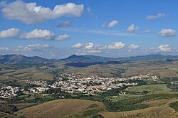
 View of Bom Jardim de Minas | |
| Nickname: BJM | |
| Motto: Omnis gloriam Dei | |
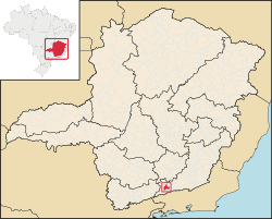
 Location in Brazil | |
| Coordinates: 21°56′15″S 41°00′58″W / 21.93750°S 41.01611°W | |
| Country | Brazil |
| Region | Southeast |
| State | Minas Gerais |
| Incorporated | December 17, 1937 |
| Government | |
| • Mayor | José Francisco Matos e Silva, PSD |
| Area | |
| • Total | 395 km2 (152.5 sq mi) |
| Elevation | 1,119 m (3,671 ft) |
| Population (2020[1]) | |
| • Total | 6,459 |
| • Density | 15/km2 (10/sq mi) |
| Time zone | UTC−3 (BRT) |
| Postal Code | 37310-000 |
| Area code | +55 32 |
| Website | Bom Jardim de Minas, Minas Gerais |
Bom Jardim de Minas is a city of the state of Minas Gerais, Brazil.
The name means Good Garden of Minas (Gerais).
It is situated in the southern part of Minas Gerais and in the middle of the Mantiqueira Mountains, at 1,200 meters high, which gives the city a mild climate.
The only paved road that reaches Bom Jardim de Minas is the BR-267, which connects the city to the southern part of the State of Minas Gerais and the region of Juiz de Fora.
Population: 6,459 inhabitants.
It was founded in 1770 with the formation of a farm land in current city. When it came near the farm houses, became a parish and then the district with the installation of the chapel on May 2, 1856. And finally, in 1938, the district was upgrade to city, with two districts, headquarters and Taboão.
Currently, the city has been increasing in the festivities such as Carnival. An agricultural exhibition in May, and a feast in honour of Jesus Christ in August. Along with the natural attractions of waterfalls and mountain scenery these contribute to the tourism industry of the city.

