Bora Bora Airport Aéroport de Bora Bora | |||||||||||
|---|---|---|---|---|---|---|---|---|---|---|---|
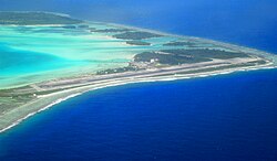
 View of Bora Bora Airport | |||||||||||
| Summary | |||||||||||
| Airport type | Public | ||||||||||
| Operator | SETIL - Aéroports | ||||||||||
| Serves | Bora Bora, French Polynesia, France | ||||||||||
| Location | Motu Mute | ||||||||||
| Elevation AMSL | 11 ft / 3 m | ||||||||||
| Coordinates | 16°26′37″S 151°45′09″W / 16.44361°S 151.75250°W | ||||||||||
| Map | |||||||||||
 | |||||||||||
| Runways | |||||||||||
| |||||||||||
| Statistics (2023) | |||||||||||
| |||||||||||
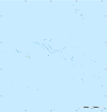
Bora Bora Airport (IATA: BOB, ICAO: NTTB), also known as Motu Mute Airport, is an airport serving the island of Bora Bora in French Polynesia. It is located on the islet of Motu Mute.[1]
The airport was opened in 1943, during World War II. Commercial service became available in 1958 after the runway was reconstructed. It is built on an island (the Polynesian word for which is "motu") located in a lagoon. A boat transfer is necessary to get to the main island of Bora Bora.[3]
Passengers from Vaitape, the largest population center on Bora Bora, usually use this airport for air travel.
- ^ a b NTTB – Bora Bora Motu Mute. AIP from French Service d'information aéronautique, effective 31 October 2024.
- ^ "Résultats d'activité des aéroports français 2018" (PDF). aeroport.fr. Retrieved 31 August 2019.
- ^ Bora Bora Airport at SETIL Aéroports Archived August 31, 2007, at the Wayback Machine
