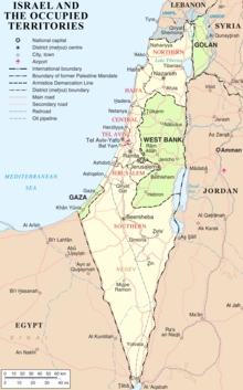
The modern borders of Israel exist as the result both of past wars and of diplomatic agreements between the State of Israel and its neighbours, as well as an effect of the agreements among colonial powers ruling in the region before Israel's creation. Only two of Israel's five total potential land borders are internationally recognized and uncontested, while the other three remain disputed; the majority of its border disputes are rooted in territorial changes that came about as a result of the 1967 Arab–Israeli War, which saw Israel occupy large swathes of territory from its rivals.[1] Israel's two formally recognized and confirmed borders exist with Egypt and Jordan since the 1979 Egypt–Israel peace treaty and the 1994 Israel–Jordan peace treaty, while its borders with Syria (via the Israeli-occupied Golan Heights), Lebanon (via the Blue Line; see Shebaa Farms dispute) and the Palestinian territories (Israeli-occupied land largely recognized as part of the de jure State of Palestine) remain internationally defined as contested.[2]
According to the Green Line agreed upon in the 1949 Armistice Agreements, Israel is demarcated by Lebanon to the north, the Golan Heights under Syrian sovereignty as well as the rest of Syria to the northeast, the Palestinian West Bank and Jordan to the east, and by the Palestinian Gaza Strip and Egypt to the southwest. The Israeli border with Egypt is the international border demarcated in 1906 between the United Kingdom and the Ottoman Empire, and confirmed in the 1979 Egypt–Israel peace treaty; the Israeli border with Jordan is based on the border defined in the 1922 Trans-Jordan memorandum, and confirmed in the 1994 Israel–Jordan peace treaty.
- ^ Newman, David (March 28, 2012). "Borders and Conflict Resolution". In Thomas M. Wilson and Hastings Donnan (ed.). A Companion to Border Studies. John Wiley & Sons. pp. 252–. ISBN 978-1-118-25525-4.
Unique to states in the contemporary world, only two of Israel's five potential land borders have the status of internationally recognized boundaries.
- ^ Sela, Avraham. "Israel." The Continuum Political Encyclopedia of the Middle East. Ed. Sela. New York: Continuum, 2002. pp. 444-474