This article needs additional citations for verification. (June 2013) |
| Boronia Melbourne, Victoria | |||||||||||||||
|---|---|---|---|---|---|---|---|---|---|---|---|---|---|---|---|
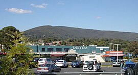
 Looking east towards One-tree Hill | |||||||||||||||
 | |||||||||||||||
| Coordinates | 37°51′43″S 145°17′10″E / 37.862°S 145.286°E | ||||||||||||||
| Population | 23,607 (2021 census)[1] | ||||||||||||||
| • Density | 2,089/km2 (5,411/sq mi) | ||||||||||||||
| Postcode(s) | 3155 | ||||||||||||||
| Elevation | 120 m (394 ft) | ||||||||||||||
| Area | 11.3 km2 (4.4 sq mi) | ||||||||||||||
| Location | 29 km (18 mi) E of Melbourne CBD | ||||||||||||||
| LGA(s) | City of Knox | ||||||||||||||
| County | Mornington | ||||||||||||||
| State electorate(s) | Bayswater | ||||||||||||||
| Federal division(s) | Aston | ||||||||||||||
| |||||||||||||||
Boronia is an eastern suburb in Melbourne, Victoria, Australia, 29 km east of Melbourne's Central Business District, located within the City of Knox local government area. Boronia recorded a population of 23,607 at the 2021 census.[1]
The area was originally occupied by the Wurundjeri, Indigenous Australians of the Kulin nation, who spoke variations of the Woiwurrung language group.
- ^ a b Australian Bureau of Statistics (28 June 2022). "Boronia (Suburbs and Localities)". 2021 Census QuickStats. Retrieved 14 July 2022.
