Bedford
Borough of Bedford | |
|---|---|
| |
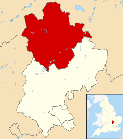
 Bedford shown within Bedfordshire | |
| Coordinates: 52°8′0″N 0°27′0″W / 52.13333°N 0.45000°W | |
| Sovereign state | |
| Country | |
| Region | East of England |
| Ceremonial county | Bedfordshire |
| Administrative HQ | Borough Hall, Bedford |
| Government | |
| • Type | Unitary Authority |
| • Governing body | Bedford Borough Council |
| • MPs | Richard Fuller (C) Alistair Strathern (L) Mohammad Yasin (L) |
| Area | |
| • Total | 476 km2 (184 sq mi) |
| Population (2022)[1] | |
| • Total | 187,466 |
| • Rank | 108th |
| • Density | 393/km2 (1,020/sq mi) |
| Ethnicity (2021) | |
| • Ethnic groups | |
| Religion (2021) | |
| • Religion | List
|
| Time zone | GMT |
| • Summer (DST) | British Summer Time |
| ONS code | 00KB |
| NUTS 3 | UKH22 |
| ISO 3166-2 | GB-BDF |
| Website | bedford |
Bedford, or the Borough of Bedford, is a unitary authority area with borough status in the ceremonial county of Bedfordshire, England. The council is based in Bedford, the borough's namesake and principal settlement, which is the county town of Bedfordshire.
The Bedford built-up-area is the 71st largest in the United Kingdom and also includes Kempston and Biddenham.[3] Away from the Bedford built-up area the borough includes a large rural area with many villages. 75% of the borough's population live in the Bedford built-up and the five large villages which surround it, which makes up slightly less than 6% of the total land area of the borough.
The borough is also the location of the Wixams new settlement, immediately south of Bedford, which received its first residents in 2009.
- ^ "Mid-Year Population Estimates, UK, June 2022". Office for National Statistics. 26 March 2024. Retrieved 3 May 2024.
- ^ a b UK Census (2021). "2021 Census Area Profile – Bedford Local Authority (E06000055)". Nomis. Office for National Statistics. Retrieved 5 January 2024.
- ^ UK Census (2011). "Local Area Report – Bedford Built-up Area (E34004993)". Nomis. Office for National Statistics. Retrieved 26 July 2019.


