Borsele
Bossele (Zeeuws) | |
|---|---|
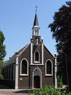
 Church in Ovezande | |
 Location in Zeeland | |
| Coordinates: 51°26′N 3°49′E / 51.433°N 3.817°E | |
| Country | Netherlands |
| Province | Zeeland |
| Government | |
| • Body | Municipal council |
| • Mayor | Gerben Dijksterhuis (ChristianUnion) |
| Area | |
| • Total | 194.52 km2 (75.10 sq mi) |
| • Land | 141.57 km2 (54.66 sq mi) |
| • Water | 52.95 km2 (20.44 sq mi) |
| Elevation | 2 m (7 ft) |
| Population (January 2021)[4] | |
| • Total | 22,818 |
| • Density | 161/km2 (420/sq mi) |
| Demonym | Borsselaar |
| Time zone | UTC+1 (CET) |
| • Summer (DST) | UTC+2 (CEST) |
| Postcode | 4430–4456 |
| Area code | 0113 |
| Website | borsele |
Borsele (Dutch: [ˈbɔrsələ] ; Zeelandic: Bossele) is a municipality in the southwestern Netherlands on Zuid-Beveland.
The name of the municipality is spelled with a single s; the name of the eponymous village is Borssele, spelled with double s.
The municipality is mainly known for the Borssele Nuclear Power Station and the Central Storage for Radioactive Waste.
- ^ "Samenstelling College van B&W" [Members of the board of mayor and aldermen] (in Dutch). Gemeente Borsele. Archived from the original on 11 December 2013. Retrieved 6 December 2013.
- ^ "Kerncijfers wijken en buurten 2020" [Key figures for neighbourhoods 2020]. StatLine (in Dutch). CBS. 24 July 2020. Retrieved 19 September 2020.
- ^ "Postcodetool for 4441AT". Actueel Hoogtebestand Nederland (in Dutch). Het Waterschapshuis. Retrieved 6 December 2013.
- ^ "Bevolkingsontwikkeling; regio per maand" [Population growth; regions per month]. CBS Statline (in Dutch). CBS. 1 January 2021. Retrieved 2 January 2022.

